
Map-based quiz games are interactive digital tools where players identify locations, countries, capitals, or landmarks directly on a map, combining education and entertainment in one format. The best examples of map-based quiz games, from Seterra to GeoGuessr, prove that geography learning works best when players interact with the map itself rather than reading static content. Whether you are a classroom instructor looking for educational map quiz apps or a trivia enthusiast hunting for fun map-based challenges, this guide covers the top platforms, their mechanics, and what makes each one worth your time.
Examples of map-based quiz games worth knowing
Before diving into individual platforms, the category itself deserves a clear definition. Geography quizzes that use maps as the primary interface are often called "interactive map quizzes" in educational technology circles, though the broader public knows them simply as map quiz games. The distinction matters because the best versions go far beyond labeling countries. They incorporate flags, capitals, historical context, and real-world imagery to create layered learning experiences.
Real-time scoring and instant visual feedback are the two features that separate engaging map quiz games from forgettable ones. Green for correct, red for incorrect, and a running score counter keep players locked in. Randomized question order prevents memorization shortcuts and forces genuine geographic recall.
Question formats vary widely across platforms. Clicking directly on a map region, typing a country name, or selecting from multiple choice options each test different cognitive skills. The strongest online geography quiz games combine at least two of these formats within a single session.
Pro Tip: When evaluating any map quiz platform for classroom use, check whether it supports fuzzy answer matching. Fuzzy matching algorithms accept common misspellings and alternate country names, which reduces player frustration and keeps students focused on geography rather than spelling.
User interface design also determines whether a quiz feels accessible or overwhelming. Clean map visuals, readable fonts, and mobile-friendly layouts are non-negotiable for any platform targeting students or casual players.
1. Seterra
Seterra is the most widely recognized free geography quiz platform online. It covers countries, capitals, flags, oceans, rivers, and cities across every continent, and it operates in over 40 languages. That language range makes it one of the few truly global educational map quiz apps available without a subscription.
What sets Seterra apart is its structured progression. Players can start with broad continent-level quizzes and drill down to individual states or provinces. A teacher assigning Seterra homework can trust that students at different levels will each find an appropriate challenge. The platform's longevity, it has been running since the late 1990s, reflects consistent demand from both classrooms and self-directed learners.
2. GeoGuessr
GeoGuessr takes a fundamentally different approach to map-based trivia. Instead of clicking labeled regions, players are dropped into a Google Street View location anywhere on Earth and must guess where they are by placing a pin on a world map. The closer the guess, the higher the score.
This immersive format appeals to exploration enthusiasts who find traditional click-on-map quizzes too passive. GeoGuessr rewards visual literacy: reading road signs, recognizing vegetation types, identifying architectural styles, and interpreting sun angles. It is one of the best map-based trivia games for older students and adult gamers who want geography challenges that feel like puzzles rather than drills.
3. Educaplay's Map Quiz Maker
Educaplay solves a problem that Seterra and GeoGuessr do not address: what if you need a quiz about a specific region, historical boundary, or custom content set? Educaplay's Map Quiz Maker lets educators build their own interactive map quizzes using a drag-and-drop editor, without writing a single line of code.
Teachers can upload a custom map image, place clickable zones, and assign correct answers to each zone. This makes it ideal for history classes covering ancient empires, science classes mapping ecosystems, or social studies units on local geography. The tool supports classroom sharing and tracks student responses, which adds genuine instructional utility beyond what general-purpose platforms offer.
4. Lizard Point Quizzes
Lizard Point offers over 200 interactive map quizzes covering countries, states, cities, flags, and capitals. The site's design is deliberately simple, which is a feature rather than a flaw. No accounts, no paywalls, no distractions. Students click a region, get immediate feedback, and move on.
The depth of content is the real draw. Lizard Point covers not just nations but also U.S. states, Canadian provinces, Australian states, and dozens of sub-national regions worldwide. For educators who need students to master a specific geographic area in detail, Lizard Point's focused quizzes outperform broader platforms that spread content thin.
5. Sporcle map quizzes
Sporcle hosts thousands of map quizzes ranging from simple country naming to complex continent identification challenges. The platform's community-created content model means new quizzes appear constantly, covering niche topics like landlocked countries, island nations, or capitals that share names with their countries.
Sporcle's timer mechanic is its defining feature. Players race against a countdown to type as many correct answers as possible, which creates a competitive pressure that pure click-on-map games lack. This format suits trivia enthusiasts who want quiz games with maps that feel like a sport rather than a study session.
6. No-code custom map quiz builders
Developers and educators who want full control over their quiz experience increasingly turn to AI-assisted no-code builders to create map quizzes with real-time scoring, leaderboards, and instant visual feedback. These tools allow anyone to build a functional map quiz web app without programming knowledge.
The practical upside for educators is significant. A teacher can build a quiz tied directly to a unit's learning objectives, embed it in a course management system, and track class-wide performance. For game developers, no-code builders lower the barrier to testing map quiz game ideas before committing to full development.
7. IRC world map quiz
The International Rescue Committee's world map quiz uses silhouettes, neighboring country clues, and landmark hints to teach geography through context rather than rote memorization. Some challenges require identifying up to 30 countries across 8 map segments, integrating multiple learning layers in a single session.
This approach works particularly well for learners who struggle with pure memorization. Presenting a country's silhouette alongside a clue about its neighbors activates spatial reasoning rather than simple recall. It is one of the more underrated interactive map quiz examples for educators who want to teach geopolitical relationships alongside location facts.
8. Multiplayer and event-style map quizzes
Live multiplayer geography quizzes represent the fastest-growing segment of map quiz game ideas. Platforms that support synchronous play, where multiple students or players compete simultaneously, generate the kind of social engagement that solo quizzes cannot replicate.
Timers, score multipliers, and leaderboards create competitive environments that motivate repeated play. A classroom running a live map quiz tournament sees participation rates that standard homework assignments rarely match. Event-style formats also work for trivia nights, geography clubs, and corporate team-building sessions where the social dimension matters as much as the content.
9. Thematic and historical map quizzes
Thematic quizzes focused on specific continents, historical boundaries, or cultural regions offer a depth that general geography quizzes miss. A quiz covering the borders of post-World War I Europe teaches history and geography simultaneously. A quiz on African capitals organized by colonial language group adds linguistic and historical context to location facts.
Customizing quiz difficulty by region and question type enhances learning retention and user satisfaction. A thematic quiz on Southeast Asian capitals hits differently than a generic world capitals quiz because the focused scope forces players to distinguish between countries they might otherwise lump together. Educators building curriculum-aligned content should treat thematic design as a core principle rather than an optional feature.
10. Flashcard-integrated map learning tools
Combining map quizzes with flashcard systems creates a study loop that reinforces location knowledge from multiple angles. A student who first reviews country flashcards and then takes a click-on-map quiz performs better than one who uses either tool alone. The map-based quiz format activates spatial memory while flashcards reinforce verbal recall.
Several educational platforms now integrate both formats in a single session. A student might see a country's flag on a flashcard, then immediately locate that country on a map. This dual-encoding approach is grounded in cognitive science and represents the direction that serious educational map quiz apps are moving.
Comparing top map quiz platforms at a glance
| Platform | Best for | Key feature | Access |
|---|---|---|---|
| Seterra | Students and self-learners | 40+ languages, structured levels | Free, web and mobile |
| GeoGuessr | Gamers and explorers | Street view immersion | Freemium, web and app |
| Educaplay | Educators building custom content | Drag-and-drop quiz creator | Free and paid tiers |
| Lizard Point | Detail-focused geography study | 200+ quizzes, no account needed | Free, web only |
| Sporcle | Trivia fans and competitive players | Timer-based community quizzes | Free and paid tiers |
Key takeaways
The best map-based quiz games combine real-time feedback, varied question formats, and audience-specific design to deliver both engagement and genuine geographic learning.
| Point | Details |
|---|---|
| Feedback drives retention | Instant visual feedback with color-coded responses keeps players engaged and reinforces correct answers. |
| Platform choice depends on audience | Students benefit from Seterra and Lizard Point; gamers gravitate toward GeoGuessr and Sporcle. |
| Custom tools fill curriculum gaps | Educaplay and no-code builders let educators create quizzes tied to specific learning objectives. |
| Fuzzy matching reduces dropout | Accepting alternate spellings and country names keeps players focused on geography, not typing accuracy. |
| Multiplayer format multiplies engagement | Live competitive quizzes generate participation rates that solo formats rarely achieve. |
Why I think most people underestimate map quiz games
I have used map quiz games in both casual and structured learning contexts for years, and the pattern I keep seeing is the same: people assume these tools are only for kids memorizing capitals. That assumption misses most of what makes them powerful.
GeoGuessr, for instance, has taught me more about how to read a landscape than any geography textbook I encountered in school. Recognizing that a particular shade of red soil combined with a specific road marking style points to Western Australia is a skill that transfers to real-world spatial awareness. That is not trivial.
What I find most interesting is how the feedback loop changes behavior. When a quiz shows you exactly where you went wrong on a map, you do not just note the mistake. You visualize the correct location, which encodes it differently than reading a correction in text. Platforms that skip this visual feedback step are leaving the most valuable part of the learning mechanism on the table.
For educators, my honest recommendation is to stop treating map quizzes as review tools and start using them as primary instruction. A well-designed interactive map quiz, especially one with thematic focus and layered metadata, can introduce a geographic concept more effectively than a lecture. The engagement is built in. You just have to choose the right platform for your audience.
— Pran Gran
Test your geography skills on Worldlecity
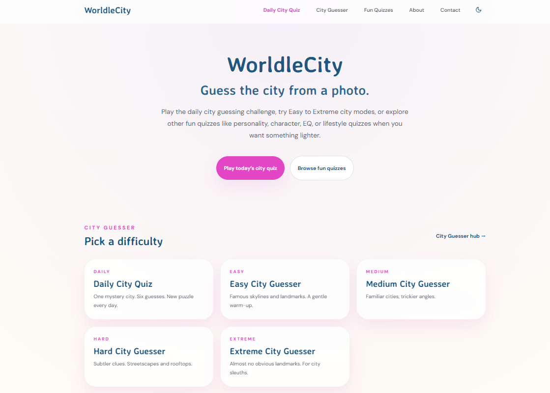
Worldlecity brings the city-guessing format to daily players who want a fast, satisfying geography challenge without the setup of a full quiz session. Each day presents a new city to identify using visual clues, making it one of the most accessible fun map-based challenges available for both casual gamers and educators looking for a low-friction warm-up activity. The platform also features quizzes on lifestyle, characters, and personality, so geography fans can explore beyond the map. If this article gave you a list of platforms to explore, Worldlecity is the one to bookmark for your daily practice.
FAQ
What are the best free map quiz games online?
Seterra and Lizard Point are the strongest free options for structured geography study, while Sporcle offers the widest variety of community-created map quizzes at no cost.
How do map-based quiz games help with learning?
Map-based quiz games use instant visual feedback and spatial interaction to encode geographic information more effectively than text-based study. Clicking or placing a pin on a map activates spatial memory alongside factual recall.
What makes a map quiz good for classroom use?
A classroom-ready map quiz needs clear visual feedback, customizable difficulty, and ideally a way to track student performance. Educaplay and no-code quiz builders address all three requirements for educators.
Can map quiz games work for competitive trivia?
Sporcle's timer-based format and GeoGuessr's scoring system both support competitive play. Adding leaderboards and score multipliers, as research on competitive quiz features confirms, significantly increases motivation for repeated play.
What is fuzzy matching in map quiz games?
Fuzzy matching is a feature that accepts minor typos and alternate country names as correct answers. It prevents player frustration from rigid input rules and keeps the focus on geographic knowledge rather than precise spelling.